Climate change impacts
Remote imaging can be used to track climate change impacts over time.
Remote imaging can easily be used to track a number of climate change impacts: land loss, flooding and stream bank changes, droughts impacting grazing or agriculture and wind and storm impacts. Shifts in the landscape caused by climate change can be tracked fairly easily with satellite imagery, particularly when current imagery is compared with recent or historical imagery.
For example, images were taken of natural lands throughout the United States during the 1930s. These historical images can be a great resource for organizations seeking to understand how climate change has impacted their region over time.
Baselines
In areas of the country where there are few historical images or the resolution of these images is not fine enough, organizations have been using high-resolution imagery to create baselines to track climate change moving forward.
The accredited Teton Regional Land Trust (ID) shared:
It has been really helpful for diving into climate change adaptation. We used it just before a ground visit. We want to establish a baseline for a riparian bank restoration because it is helpful to see where bank has been deteriorating and we were able to have a report for the visit with state and federal partners.
The accredited Mount Grace Land Conservation Trust (MA) added:
We use aerial imagery to create baselines to track ecological changes and use for prospective property planning.
Coastal land loss
Remote images can show real-time changes to coastal and island properties. Although land loss is a significant issue for land trusts, it can be difficult to monitor in real time. Once land loss has been identified, land trusts can work toward implementing adaptations, such as promoting accretion or adding soil to raise the marsh and protecting at-risk areas of marshland. Mitigation and carbon sequestration strategies can also be employed, such as planting trees or other vegetation types to promote carbon absorption and connecting fresh and saltwater ecosystems to produce brackish water, which sequesters twice as much carbon.

Flooding and stream or riverbank changes
Remote images can show the real-time impacts of flooding on streams or riverbanks. Monitoring stream bank structures after high flow events can help land trusts decide on the best course of action to protect from bank erosion into the future. Water indices can also show water quality and can be used to convey the importance of climate adaptation efforts to partners and the public. Riverbank changes can take several forms: changes that create more land area due to agricultural runoffs and changes to the flow of the stream or river.
Once the issue has been identified, land trusts can work toward changes, such as limiting future development and stream bank stabilization by selecting native species and removing invasive species. Other mitigation strategies include planting trees or other vegetation types to promote carbon absorption.


Drought, grazing and agriculture
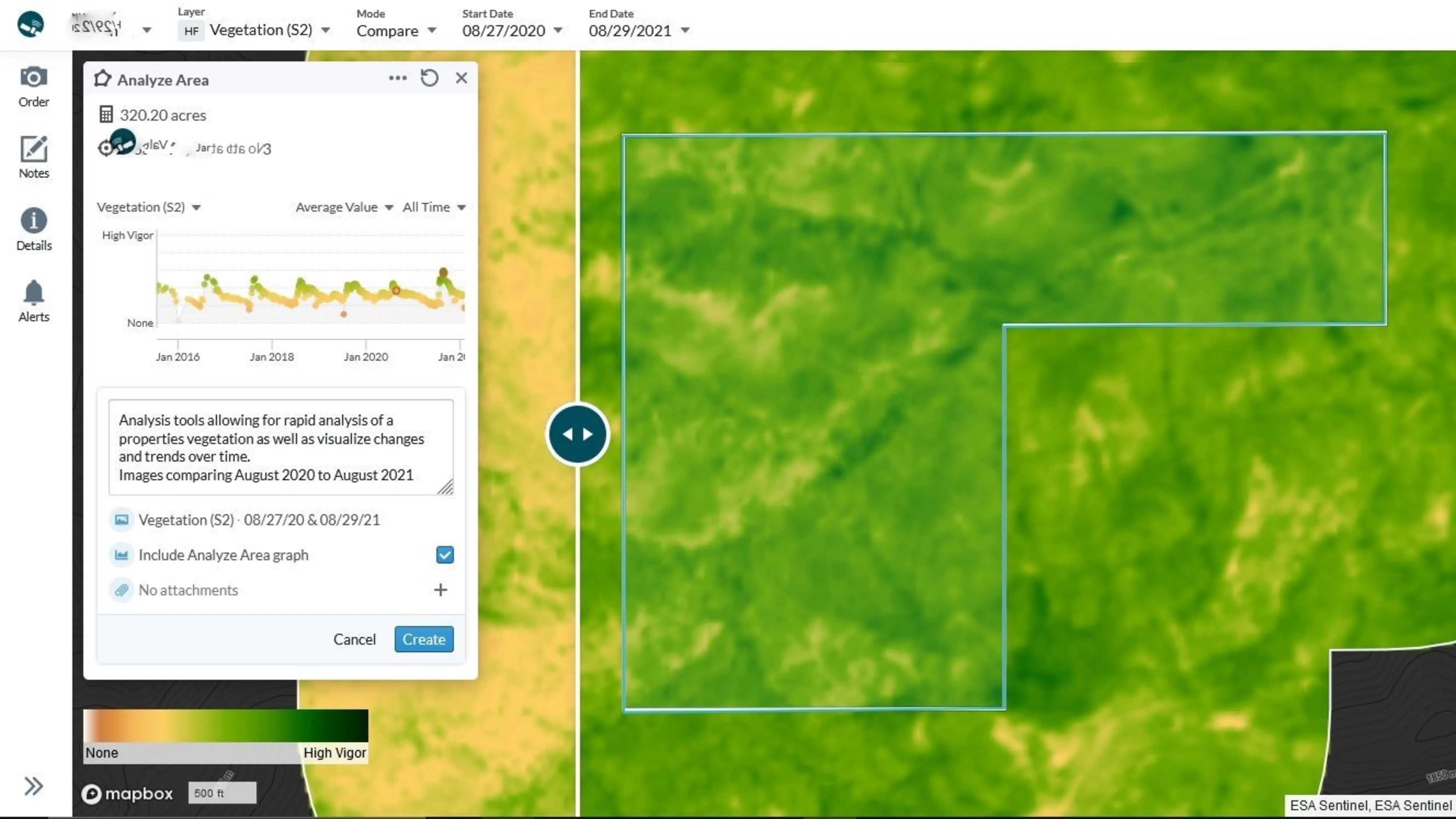
Remote images can show the real-time impact of drought conditions on grazing and agricultural fields and produce multiple views of a property at different times throughout the year. Multispectral imaging can more easily show drought conditions through lens like LiDAR and NIR (near infrared). Once the issue has been identified, land trusts can implement adaptations such as selecting plant species that will thrive in new conditions, increasing species diversity, removing invasives and changing field rotations or crop types. Land trusts can also employ mitigation strategies, such as selecting crops that can absorb more carbon or keeping land in grazing to avoid the release of carbon in the soil when tilled for agriculture. The two images below show the same property one year apart and show a clear difference in vegetation health caused by changing moisture conditions.

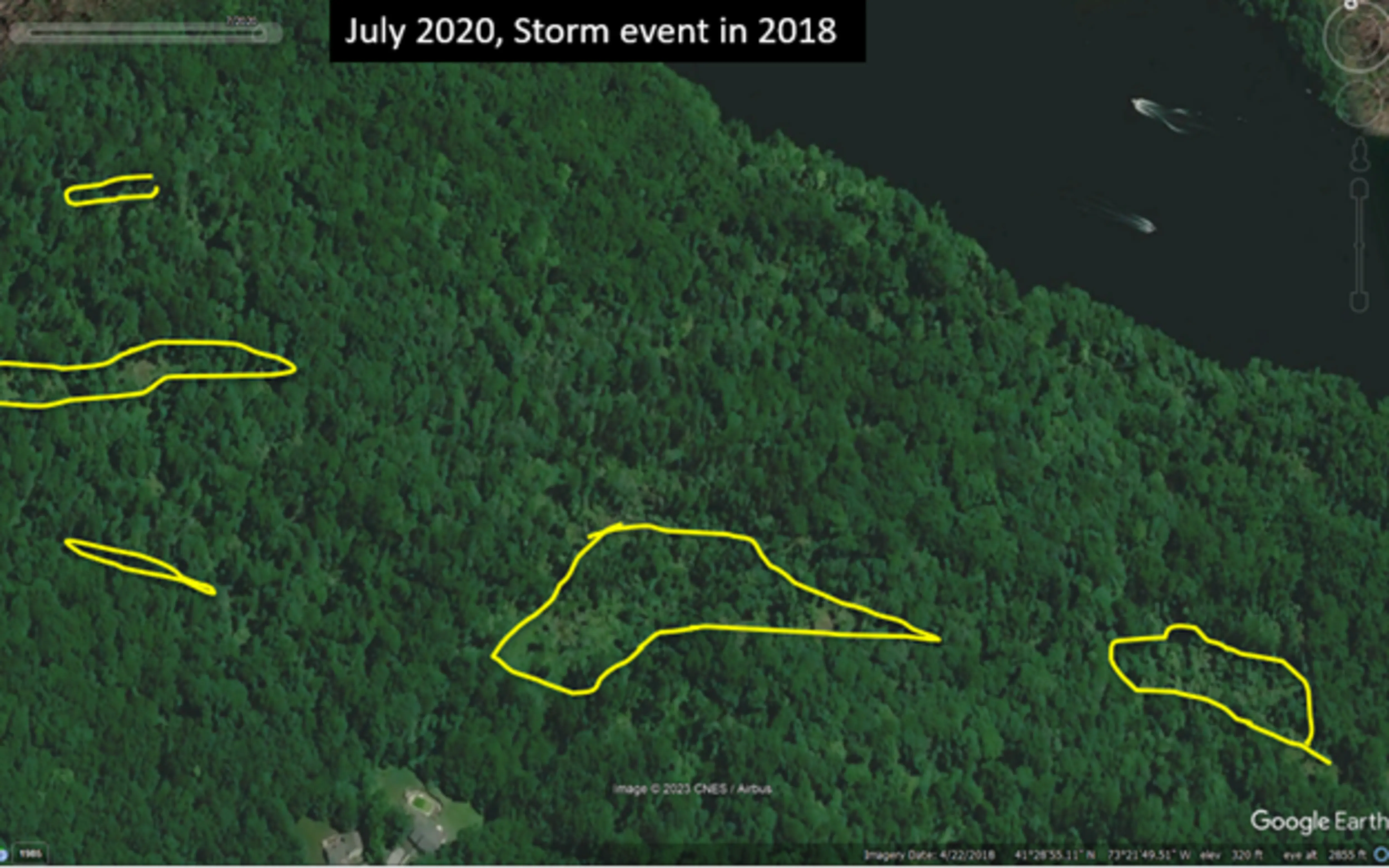
Impacts of storms and high wind events
We used printed satellite imagery after Hurricane Ida. The storm changed streambanks radically—using imagery we could tell direction of water, which was helpful to use for damage control and restoration planning.
—Hunterdon Land Trust
Remote images can show real-time changes to landscapes impacted by storms and high wind events. Monitoring post-storm events can help land trusts decide on the best course of action to protect ecosystems in the future. The example below from the Birch Rocks Sanctuary in Brookfield, Connecticut, shows gaps in the forest canopy that were caused by a high wind event. Land trusts can implement adaptations such as changing trail locations and managing invasives and mitigation strategies such as promoting certain tree species.