Lake Pontchartrain Basin Foundation Resiliency Planning
Source

About This Case Study
The Lake Pontchartrain Basin Foundation works to restore and preserve natural resources and supports resiliency planning throughout the watershed.
© 2015 Land Trust Alliance, Inc. All rights reserved.
The Lake Pontchartrain Basin Foundation was formed in 1989 to address watershed issues, in large part due to the fact that the 630 square mile brackish estuary located just north of New Orleans was closed due to pollution. The Basin itself is a 10,000 square mile watershed encompassing 16 Louisiana parishes, including nearly all of Louisiana east of the Mississippi River. As its first action, LPBF began the SAVE OUR LAKE campaign working to restore Lake Pontchartrain for the public to use as a healthy economic and recreational resource. In 1995, the Comprehensive Management Plan was finalized in a joint effort with the U.S Environmental Protection Agency and numerous other agencies and stakeholders. These contributors exhaustively cataloged the threats to the Basin by sewage, agricultural and urban runoff, saltwater intrusion and wetlands loss. The CMP has served as the road map for LPBF programs and projects. The SAVE OUR LAKE campaign was a marked success, and Lake Pontchartrain was removed from the impaired water bodies list in 2006. LPBF continues to address water quality issues throughout the region, and in 2005, created a Comprehensive Habitat Management Plan that provides goals, strategies and methods designed for Basin sustainability.
In June 2005, to address CHMP goals and further its mission to restore and preserve the natural resources of the Pontchartrain Basin, LPBF created a formal coastal sustainability program. LPBF devised the Multiple Lines of Defense Strategy which identified ten priority project areas, leading to the Pontchartrain Coastal Lines of Defense Program. LPBF’s latest efforts reach across the entire Louisiana coast with a broader plan called the Louisiana Coastal Lines of Defense. The plan uses the MLODS to set habitat goals and identify manmade and natural defenses that the State and Federal agencies can use to help provide coastal sustainability and storm protection for Louisiana.
The PCLOD Program’s Bayou St. John Marsh Creation Project exemplifies the LPBF’s comprehensive approach to preserving conservation values, with goals of:
Value of the land and habitat
The Lake Pontchartrain Basin is a 10,000 square mile watershed encompassing 16 Louisiana parishes. The land use of the region is both rural and urban. It is the most densely populated region in Louisiana, including metro New Orleans and the state capital, Baton Rouge. The Basin is one of the largest estuarine systems in the Gulf of Mexico and contains over 22 essential habitats and numerous rare plants. The Basin’s topography ranges from rolling woodlands in the north to coastal marshes in the south, with the 630 square mile Lake Pontchartrain as its centerpiece.
Conservation concerns
This unique ecosystem is dominated by an estuarine system that is essential to the future of southeast Louisiana. The Pontchartrain Basin is 19% (about 10,000 square miles) of Louisiana’s area and has within it 46% of the state’s population (or 2.1 million people). Based on imagery from 1992 to 1995, the entire basin was estimated to hold 2,100 square miles of marshes and swamps. The area of all wetlands and open water which composes the Pontchartrain Basin estuary is 5,800 square miles. From 1932 to 2001, 415 square miles of these wetlands were converted to open water or upland habitat, and the rate of loss has dramatically increased in the last decade (1990 – 2001). Preliminary estimates suggest that Hurricane Katrina in 2005 caused at least as much loss of marsh as in this entire prior decade (~80 square miles).
Decades of poor stewardship of the region’s natural resources triggered the founding of the Lake Pontchartrain Basin Foundation in 1989, which was given the mission to restore and preserve the Pontchartrain Basin. In 1995 LPBF developed a Comprehensive Management Plan for the Pontchartrain Basin. The final step of the initial CMP development, Phase III, detailed three key environmental issues in the region: storm water, sewage and saltwater intrusion and wetland loss.
In 2004, a Comprehensive Habitat Management Plan — Draft Committee was created to evaluate impairments and restoration alternatives for habitats in the Pontchartrain Basin. During the analysis and drafting process, new data were made available which indicate accelerated land loss rates in the Pontchartrain Basin and thus added greater justification and urgency to the completion of priority restoration objectives.
Process of developing comprehensive management plan
The Lake Pontchartrain Basin Foundation developed a Comprehensive Management Plan jointly with the U.S Environmental Protection Agency and numerous other federal, state and local agencies, elected officials, area universities, sporting and recreational organizations, citizens groups, commercial fishing organizations and representatives from the agricultural community and the business community. The process began in 1991 with meetings of experts and the public, and concluded with recommended action items. Contributors exhaustively cataloged the threats to the Basin by sewage, agricultural and urban runoff, saltwater intrusion, and wetlands loss, and suggested mitigation measures to address cumulative impacts on the Basin’s water quality and habitats. The CMP reflects a systematic approach to addressing the ecological, as well as socio-political causes of degradation in the Basin.
The Plan was conducted in three phases. In Phase I, the CMP worked to summarize public meetings, highlighting numerous community identified concerns or potential challenges to restoring the Lake Pontchartrain Basin. The Phase I reports, published in 1992, allowed LPBF to identify objectives for enhancing pollution control, institutional planning and regulation, education and outreach, and limiting use activities on the lake, developing a “road map for restoration.” In Phase II, partners worked to develop an “Action Items Agenda” and the “Report to the People of the Lake Pontchartrain Basin”, which was published in 1993. Phase III was concluded with the publication of the “Recommendations Addressing Sewage, Agricultural Runoff, Stormwater Runoff, Saltwater Intrusion and Wetland Loss” in 1995. Projects implementing many of the proposed activities remain ongoing.
Building on the successful partnership that yielded the Comprehensive Management Plan, the Lake Pontchartrain Basin Foundation continued the momentum to address critical conservation challenges in the region. By 2004, new data was available and a Comprehensive Habitat Management Plan Draft Committee was created to evaluate impairments and restoration alternatives for habitats in the Pontchartrain Basin. The Committee’s Comprehensive Habitat Management Plan.was published in 2005, providing over 100 project recommendations to enhance habitat throughout the area. Ten of these were selected for immediate implementation to achieve habitat restoration and build coastal resilience.
Process of developing and implementing “multiple lines of defense”
To address CHMP goals, LPBF created a Coastal Sustainability Program in June of 2005. Shortly before Hurricane Katrina, LPBF devised the Multiple Lines of Defense Strategy. From this strategy the Pontchartrain Coastal Lines of Defense Program was created. This program is a set of 10 projects and guidelines offered by LPBF to Federal and State agencies as the best way to provide coastal restoration and hurricane protection in the Basin. Additionally, out of MLODS came LPBF’s SAVE OUR COAST campaign as part of the commitment to educate the citizenry on the importance of restoring our coastal wetlands, protecting wetland habitats, and providing flood protection across all of South Louisiana.
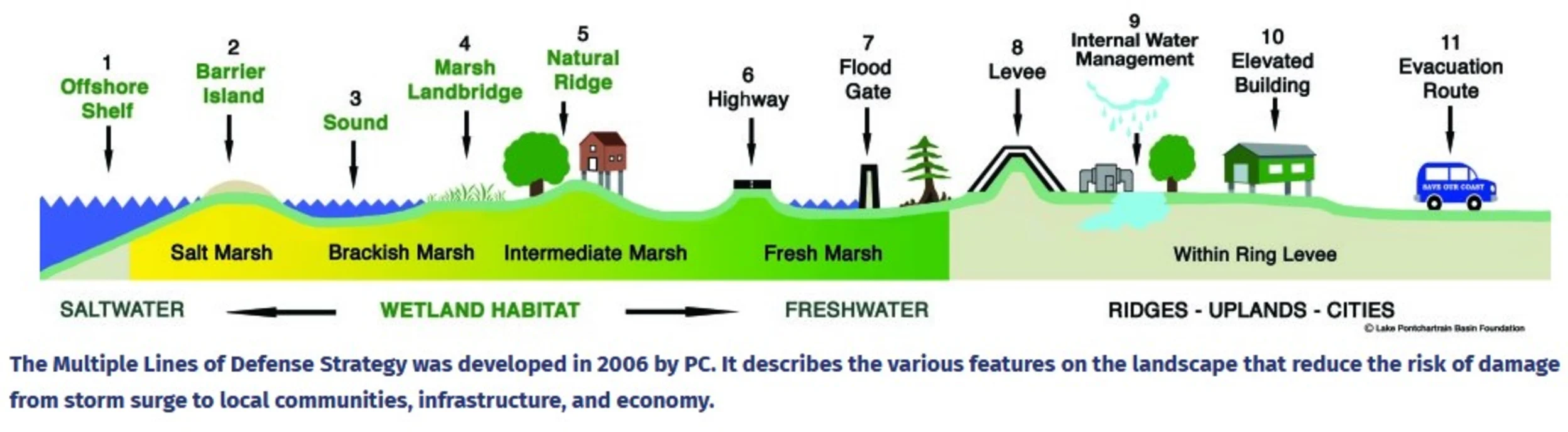
LPBF’s latest efforts reach across the entire Louisiana coast with a broader plan called the Louisiana Coastal Lines of Defense. The plan uses the MLODS to set habitat goals and identify man-made and natural defenses that the State and Federal agencies can use to help provide coastal sustainability and storm protection for Louisiana. This strategy has been accepted by the Army Corps of Engineers and is reflected in the Louisiana State Plan.
Plans for the future
About 49% of New Orleans is below sea level, and the city and surrounding regions are committed to building resilience. Habitat restoration and conservation remain a pressing objective to help protect ecosystems and the communities that rely upon them from threats of sea level rise and increased storm extents and frequencies. Thanks to strong, ongoing partnerships and growing public support, efforts to mitigate and adapt to coastal hazards in Louisiana will continue.
Engaging stakeholders
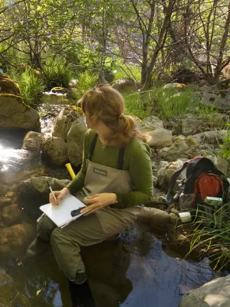
The LPBF actively engages community members who in turn are often excited to support shared objectives — better water quality is a pretty compelling cause. The LPBF reaches out to the community, hosting booths at events and offering trainings and activities where stakeholders could learn about coastal issues. In addition to developing teaching guides, the Water Watch Program that involves classrooms in water quality monitoring and offering fieldtrips, LPBF also trains water safety instructors and teaches swimming lessons. Outreach and word of mouth have grown the group’s volunteer base to between 3000-4000. Often with the support of local sponsors, the Foundation holds periodic events such as fishing rodeos, festivals and an annual beach sweep in conjunction with Ocean Conservancy International that draws 1500-2000 participants annually.
Key partners
Partnerships are key, and the LPBF works hard to collaborate with others and stay in the public eye. The Foundation often offers booths or tables at local events, and is frequently sponsored by local businesses.
Partners on the Comprehensive Habitat Management Plan Committee
Lessons learned
-
Get the word out.
Connect with people about things they care about, and you will get results.
-
Speak to people face to face – that’s how you get to their heart.
People are much more receptive when you tell your story in person. You can do that in many ways, such as broadening reach with volunteers, education programs, events and social media.
-
Embrace opportunities to learn and teach.
Much of the policy work at LPBF is supported by scientific research that the Foundation either conducts themselves or works with reputable academic institutions and other professional firms to develop. This information is critical in developing sound environmental policies. Additionally, the community and regulators are increasingly receptive to messages that are grounded in sound and reliable scientific research.

Lake Pontchartrain Basin Foundation
Location: Lake Pontchartrain Basin, a 10,000 square mile watershed encompassing 16 Louisiana parishes.
Lake Pontchartrain Basin Foundation was established in 1989 and has worked on coastal restoration projects throughout the 10,000 square miles of the Basin, with Pearl River to the East, Mississippi River to the West. There are 18 staff members, 13 board members, with around 2,000 volunteers annually, and more than 20,000 volunteers involved in campaigns since 1991.
Bayou St. John Marsh Creation Project
Bayou St. John is an urban resource that not only holds incredible potential for today’s users, but also links residents and visitors to the historical development of the city of New Orleans. The bayou began naturally due to drainage from the Mississippi River to Lake Pontchartrain. The remaining waterways are utilized for aesthetics and recreation. To ensure that the multiple benefits of the bayou are continuously realized there must be coordination among jurisdictional managing entities and understanding and support from the public. In late 2004, the Bayou St. John Committee was established with a mission to identify sustainable methods to benefit Bayou St. John water quality, habitat management, recreational access and educational opportunities.
-
.5 acres
-
Tidal marsh
-
Rangia cuneata clams
Migratory marsh birds
-
Open to the public