Integrating Adaptation into Conservation Planning
Source
About This Case Study
In Rhode Island, South Kingstown Land Trust's vulnerability assessment and planning efforts identify goals, natural resource assets and management priorities to support adaptation.
© 2026 Land Trust Alliance, Inc. All rights reserved.
Disclaimer
These resources are provided "as is" for informational purposes only, without warranty of any kind. They do not constitute legal or professional advice and do not create an attorney-client relationship. They may not reflect current legal developments and should be adapted for your organization with qualified professional help. The Alliance is not liable for any damages arising from use of or reliance on these resources. Views in individual posts and third-party links/logos are not Alliance endorsements. The Alliance is committed to equal opportunity and does not condone unlawful discrimination.
For accreditation-related materials, please also consult the Land Trust Accreditation Commission website.
Rhode Island has one of the highest population densities in the United States, yet the state’s landscapes remain relatively intact with nearly sixty percent of its land area classified as forest. Strong conservation policies and the ongoing commitment from public, private and non-profit institutions have been critical to enhancing conservation of natural habitats, open space, agricultural lands and other key elements in preserving ecosystem services and associated quality of life. Despite this historic land ethic, natural spaces in Rhode Island are facing growing management challenges due to changing climatic conditions.
Rhode Island’s current planning efforts related to climate change and natural resources have been primarily at the state level. Such efforts include the establishment of the Rhode Island Climate Change Commission with its three working groups (including the Natural Resources and Habitats group), modeling of wetland migration with sea level rise, and updating of the state’s Comprehensive Wildlife Conservation Strategy to include a climate change perspective in management strategies. While this vital work is being performed at the governmental level, it is also important for local conservation organizations, such as land trusts, to consider and plan to address the reality of a changing climate. To this end, the University of Rhode Island’s Sea Grant adaptation pilot project has been working with local conservation groups to develop baseline data necessary to inform management decisions. Their project report, available here, outlines a scalable five-step approach for assessing vulnerability and monitoring both adaptation actions and habitat changes. These changes create a new set of challenges and opportunities that have the potential to greatly affect the conservation strategies of these organizations. The South Kingston Land Trust participated in the Rhode Island Sea Grant’s pilot project, and their completion of a vulnerability assessment and climate change responsive conservation planning for their land holdings can serve as an example for other land trusts seeking to address current and future conservation challenges.
Value of the land and habitat
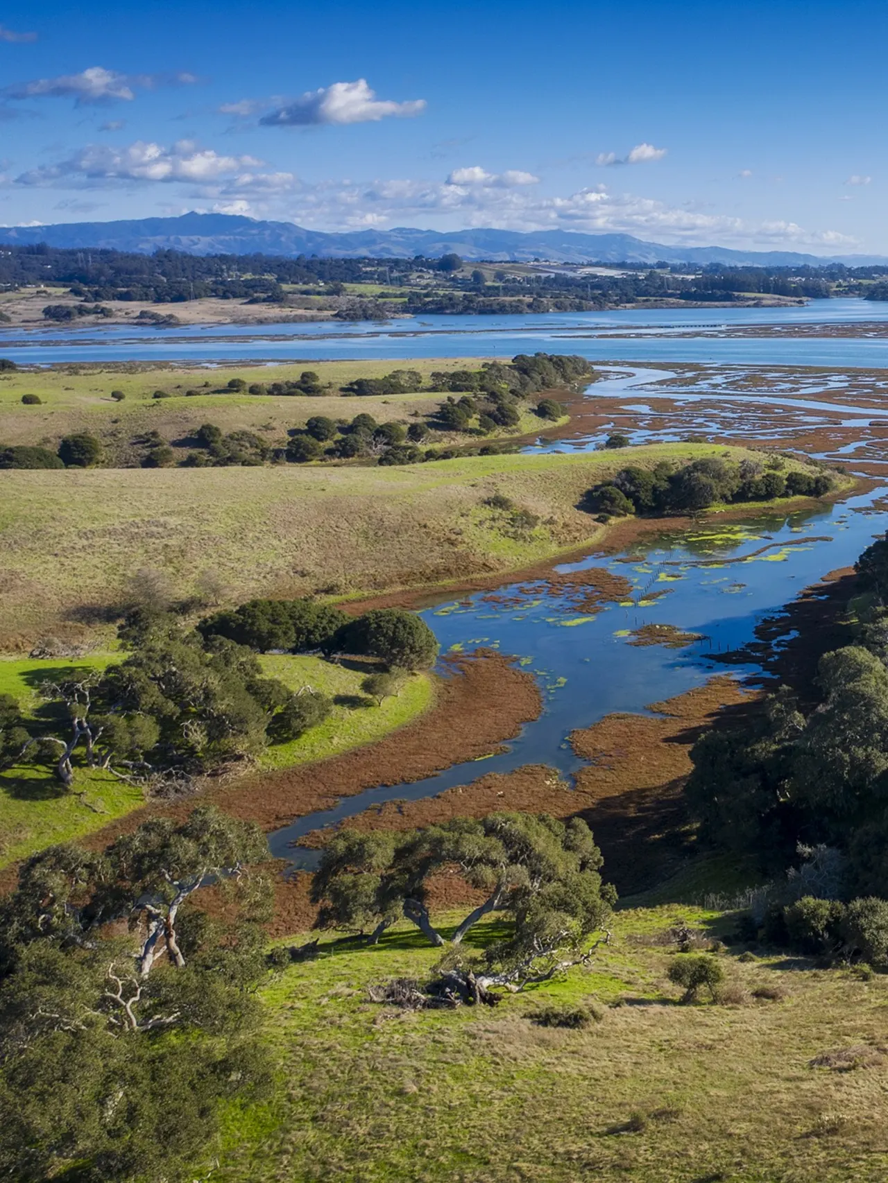
The town of South Kingstown contains important coastal and upland landscapes and valuable ecosystems. The town is located on part of the southern Rhode Island terminal moraine with extremely well-drained soils, upland forests that are primarily comprised of a mixed pine-oak overstory, and large parcels used as cropland and pasture, as well as a trout hatchery and recreational hiking areas are also present. The town’s unique location and the presence of important and rare habitats has resulted in major conservation efforts within the town, leading to the protection of approximately one-third of the municipality by various conservation organizations including SKLT. SKLT’s primary goals are habitat and species conservation, sustaining agricultural uses of the town’s landscape, groundwater protection and maintaining open space for passive recreation and community attractiveness. This land trust primarily pursues acquisition of properties based on its main objectives and goals; however, opportunistic acquisitions of properties are also made. The majority of SKLT’s protected properties are forested or farmed. Historically SKLT has been less focused on shorelines, floodplains and riparian buffers because the high acquisition costs and the fact that other organizations pursue such lands.
SKLT utilizes multiple criteria in setting priorities for land acquisition and management. These criteria are reflected in their main objectives, which include:
Conservation concerns
Since 2010 Rhode Island has experienced several major storm events causing widespread power outages, major coastal and inland flooding, and significant damage to homes, property, and infrastructure. These increasingly frequent major storms are indicative of changing variability in climactic patterns effecting Rhode Island, and it is important to recognize that the impacts of climate change have a profound effect on the state’s valuable ecosystems and habitats as well as buildings and infrastructure. One of the major impacts of climate change is alteration in the timing of seasonal activities, such as flowering of plant species and hatching of insects. These shifts, known as “phenological” changes, affect some species more than others, leading to increased incursion of previously southern species as their ranges shift northward and cause changes in species diversity. Changes in air and water temperatures, shifting rainfall patterns, and rising sea levels will affect the distribution and abundance of plants and animals and the health of ecosystems and the services they provide. There is already evidence of encroachment of species previously considered pests (such as kudzu) in the southern US into southern New England as well as changing breeding ranges in northern bird species. A study of plants in Concord, Massachusetts found that 27% of the plants originally documented by Thoreau are now extinct in the area and 36% are so sparsely distributed that extinction is likely in the near future. Invasive plant species such as Norway maple, garlic mustard and mile-a-minute vine are becoming established or expanding their previous habitat ranges. These factors must be taken into consideration by conservation organizations as they plan for habitat and ecosystem preservation in a climate-changing world.
Current protection status and management plan
SKLT protects and manages over 2,600 acres on over 150 properties in South Kingstown and contributes to the larger town and regional conservation strategy by partnering with the Town of South Kingstown, U.S. Fish & Wildlife Service, The Nature Conservancy, RI Department of Environmental Management and the Audubon Society of Rhode Island. To enhance conservation planning in the context of climate change, SKLT partnered with University of Rhode Island’s Sea Grant program to join a pilot study on how to integrate adaptation planning into a conservation organization’s portfolio. The pilot project, which ran from 2010 – 2012, culminated in a summary report as well as updated conservation planning and monitoring objectives at the land trust which are now being implemented.
Process of achieving protection and resilience to climate change
The pilot study and resulting report identified and employed a five step approach to integrating climate change. The approach outlined here is based on the process used by the SKLT, which chose to organize its assessment by geographic focus areas incorporating existing holdings within the context of larger landscape and habitats of interest. Other land trusts or conservation organizations could take a similar approach or choose to include all of the land areas within its borders, or to concentrate its efforts on a single drainage basin or sub-basin. While planning extents and conservation goals may change, the process described here is an example of adaptive management planning that is both scalable and accessible to the conservation community.
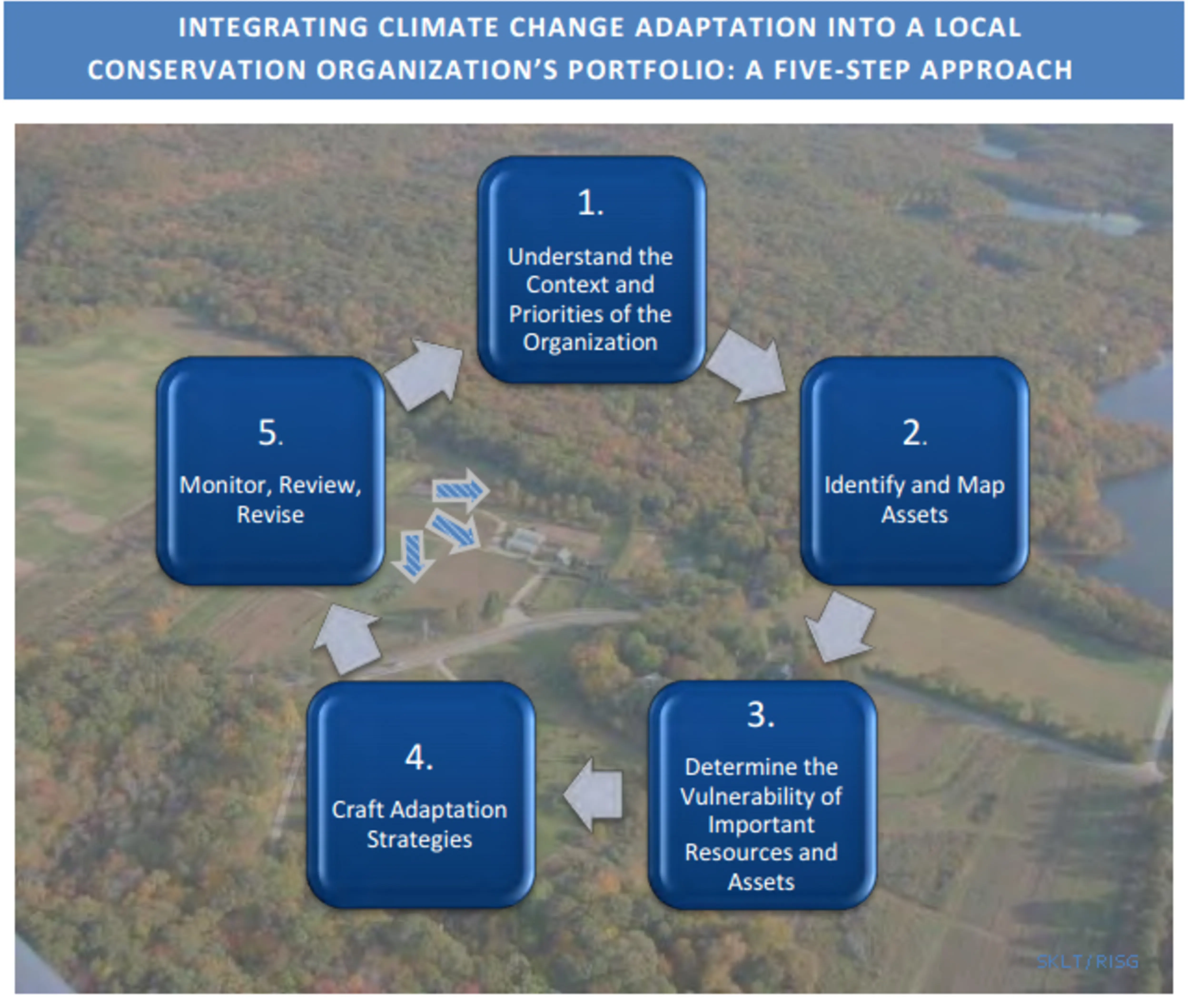
For each step, a general description is given followed by a series of guiding questions. The Rhode Island Sea Grant report includes key resources and an appendix to further assist the adaptation planning process. The iterative, five-step process for integrating adaptation into conservation planning is:
What are the goals and objectives (or mission and vision) of the organization and how do those guide land acquisition and management?
What resources are available to the organization?
Where are the organization’s assets and how best can these be represented on a map?
What is the organization’s mapping expertise level?
What information or data is available?
What do you want to map and how can this information be displayed in the most clear and informative way possible?
What potential climate factors might impact your assets? Are you already seeing climate change impacts?
What are the existing stressors to your assets?
What is the sensitivity of valued environmental and economic assets to climate change?
Can you use Ecological Land Units to determine the resilience of your habitats?
What other issues and opportunities are revealed through mapping?
What opportunities are there to include climate change considerations into conservation efforts?
How can climate change resilience be increased through no-regrets actions?
How does the organization prioritize management strategies?
How can partner organizations help in climate change adaptation efforts?
Are your management practices achieving their objectives?
Have there been unanticipated changes and what do those changes mean for the management plan?
Are there larger monitoring initiatives to which your organization can contribute to better understand local changes?
AT SKLT, habitat and species conservation, sustaining agricultural uses of the town’s landscape, groundwater protection and maintaining open space for passive recreation and community attractiveness were identified as primary organizational goals. These goals were used to identify management priorities of this conservation planning effort. Next, all of SKLT’s protected properties were collected into a dataset using GIS technology which allows the land trust to easily locate their parcels and maintain detailed records of information related to each property. An overview of the map of protected properties revealed that SKLT targeted different geographic areas for different objectives. These were labeled “focus areas” for the purpose of this project. Through this pilot project several new map products were developed to assist SKLT in managing their protected parcels and planning future acquisitions. In the future these maps and GIS databases can be updated and managed by staff or a member of SKLT with GIS skills. Next, the vulnerabilities of SKLT’s assets were determined by first mapping the habitats of each parcel and overlaying them with climate sensitivity, identified in the Connecticut Governor’s Steering Committee on Climate Change report. After identifying sensitive habitats in each focus area, SKLT reviewed the non-climate stressors faced by different assets and how they contribute to the overall climate change vulnerability. For example, Card’s Pond in SKLT’s Perryville focus area has a medium sensitivity to climate change according to the Connecticut report. This pond has a phragmites population that has resisted eradication attempts and phragmites is an invasive species that is less negatively affected by climate stressors. Therefore, this pond is more vulnerable to climate change than a similar pond where phragmites is not present even though they may have the same sensitivity. Once vulnerability factors of the valued assets such as habitats and landscapes have been determined and mapped, a strategy for increasing their resilience to climate change can be created.
Process of achieving conservation prioritization
SKLT’s first step in identifying adaptation strategies for management was to examine their current management plans and actions through a climate change lens. Following this examination several current management actions were identified that could support climate adaptation goals such as preserving healthy riparian areas bordering cold water streams and regularly monitoring for invasive species. These current management strategies may be expanded to accommodate adaptation actions (i.e. by modifying language within conservation easements to be more adaptable for climate variability and change). SKLT also identified several new adaptation actions that are consistent with the organization’s mission, priorities, and role that may be incorporated into management plans and actions. These “no regrets” actions ─ establishing good management practices to reduce drought impacts on agricultural lands and focusing acquisition on contiguous parcels in an effort to create large connected habitat areas─ provide benefits today and in a climate changing future. The SKLT Case Study targets potential adaptation and management actions pertinent to the goals of their focus areas and more specifically to different assets within these focus areas.
Plans for the future
SKLT is in the implementation and monitoring phase of its iterative adaptation planning process. Currently, SKLT organizes annual volunteer monitoring to identify any trespassing or use inconsistent with conservation easements or deed. SKLT has begun to ask monitors to keep track of changes on their protected properties, such as invasive species or timing of flowering plants. The monitoring program is volunteer-dependent; however, the program could provide a foundation for future work in tracking invasive species encroachment or species phenology changes.
Additionally, SKLT has recently joined with the URI Master Gardeners, the American Chestnut Foundation and the South County Garden Club to propagate and monitor American Chestnuts on one of the land trust’s parcels. SKLT can work with volunteers and staff of URI’s Watershed Watch, increasing their knowledge and capacity to include water quality monitoring results in their management plans as appropriate. The Director of Watershed Watch now sits on SKLT’s board. SKLT has begun to use ELU analysis in analyzing potential property acquisitions and has cited ELU diversity in a recent grant application to the State DEM for land acquisition.
Engaging stakeholders
SKLT held an informational session on the pilot project work at the Monitoring Day event in 2012, to outline the approach and goals of the project for stewardship volunteers. In SKLT’s Summer 2014 newsletter SiteLines, an article summarized the project and provided a link to the website, sklt.org, where the entire report is posted.
SKLT expects that this pilot project will inform a variety of management actions on SKLT properties and help guide land acquisition projects and priorities, so will become part of existing processes of the organization.
Key partners
Key partners that have supported the SKLT’s Climate Change Pilot Project include:
URI Sea Grant
State Coastal Resources Council
The Nature Conservancy
Audubon Society of Rhode Island
U.S. Fish & Wildlife Service
Lessons learned
Strategic conservation planning is a scalable exercise that enables land trusts to identify organizational priorities and assets in order to optimize critical stewardship efforts.
It is important to identify ecosystems and involve stakeholders when planning conservation management objectives. SKLT found the use of ELUs – Ecological Land Units – particularly helpful in mapping natural resources and identifying conservation priorities.
Adaptive management approaches help refine conservation planning. An adaptive management approach enables land trusts to reevaluate the effectiveness of monitoring and management actions at regular intervals (every 1, 2 or 3 years) and revise or make improvements as necessary. This helps land trusts address changing conditions as well as ensure management effectiveness over the longer term.
Collaboration works. Land trusts and local conservation organizations can develop and foster collaborative partnerships with other organizations as well as state agencies (such as the RI Department of Environmental Management) and national non-profits (like the Audubon Society and the Nature Conservancy) to expand their capacity and resources enabling acquisition of sensitive habitats and management of vulnerable area.

South Kingstown Land Trust
SKLT works to conserve natural resources of the Town of South Kingstown in Rhode Island
Since being established in 1983, South Kingstown Land Trust has protected 26,000 acres and has five part-time staff members and more than 850 members.
Matunuck Hills
1,656 acres (SKLT manages 234 acres of this area)
Forest (74.8% cover)
Wetlands, bogs and kettle pond shore habitats
Agriculture
Damselfly and dragonfly habitat
Several rare plant species
Most of these protected lands are not open to the public to protect the rare ecosystems found there.